
The Council of Djohong was created by Decree No. 92/127 of June 26, 1992. It initially encompassed the Djohong district and the Ngaouï district. The split was decided in 1995. The first municipal council met on February 27, 1996.
Djohong is situated at an altitude of just over 1,288 meters. It enjoys a tropical climate, a transitional type between the equatorial climate of the south and the Sudanian-Sahelian climate, with unexpected temperature variations. This climate is, however, very humid and very cold, divided between a long, seven-month rainy season from April to October and a severe, five-month dry season from November to March. July and August are very rainy, while December is marked by wintry temperatures.
The terrain of Djohong is very rugged. Hills, plateaus, and plains appear as vast grassy carpets, golden in the dry season and verdant in the rainy season, dotted with shrubs and fruit trees. The soils are primarily ferralitic, lateritic, and clayey. Its ecosystem is remarkably diverse. Gallery forests, threatened by farming activity, are found along waterways and in the Mbéré Valley, while the majority of the vegetation is composed of Sudanian-Guinean savanna, a grassy type that is gradually disappearing before a new colonizing species called « Bokassa Grass. » The flora is favorable to livestock farming and agriculture.
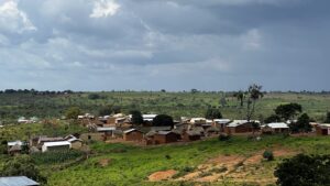
The council covers nearly three thousand square kilometers and has a population of approximately forty-eight thousand (48,000), including nearly twenty thousand Central African refugees (both within and outside the refugee camps). The main ethnic groups are the Gbaya, Fulani, Mbororo, and Mboum-Pana, who primarily rely on agriculture, cattle herding, and trade. Agriculture is practiced, with cassava cultivated for food and maize, millet, yams, and tobacco grown for sale. Trade is rudimentary and limited to small retailers. Extensive livestock farming is the preferred method, forcing herders to constantly move in search of pasture.
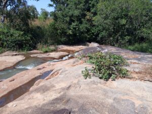
The council of Djohong is located in the Lake Chad watershed. The river, from which the Mbéré department takes its name, flows through it before joining the Logone River. The Ngou River, the Mbéré’s main tributary, punctuated by gigantic waterfalls such as the Lancrenon Falls (Gàn-zoro-ndiri in Gbaya) near the village of Yamba, forms a natural border with the Central African Republic. Several varieties of fish can be found there: catfish, Nile perch, carp, bullhead catfish, redtail fish, and more.
0-4608×3466-0-0#
The Commune is home to the Mbéré Valley National Park, which stretches across nearly 77,000 hectares along the Mbéré River, between the Bélel district to the west, the Touboro district to the north, and the Djohong district. Elephants, primates, and other small mammals roam peacefully under the watchful eyes of the park rangers. Guinea fowl, partridges, and green pigeons greet visitors with calls and cackling. The park also boasts charming tourist sites, some of which bear inscriptions commemorating the origins of the Gbaya people in the Mbéré Valley and the villages of the district: Tawan Peak (a gigantic granite mountain over 150 meters high, its slope offering breathtaking views), the Zàà Cave, the Bùù-yii waterfalls, and more. They provide a peaceful treat for hiking enthusiasts…
Torra Bell, Focal Point